

The Flood Hazard Maps and the Flood Risk Maps in the 2nd cycle (2016-2021)
Review and update of flood hazard maps (FHM) and flood risk maps (FRM) in II planning cycle was financed from the funds of the Operational Programme Infrastructure and Environment 2014-2020, Priority axis II: Environmental protection, including adaptation to climate change, Measure 2.1 Adaptation to climate change with protection and improvement of resilience to natural disasters, in particular, natural disasters and environmental monitoring.
Detailed scope and requirements of flood hazard maps and flood risk maps preparation, as well as map scale, was specified in Regulation of Minister of Maritime Economy and Inland Navigation of 4th October 2018, on the development of flood hazard maps and flood risk maps (Journal of Laws of 2018, item 2031).
Flood hazard maps and flood risk maps are drawn up for the areas and types of floods indicated in the preliminary flood risk assessment (PFRA). As a result of review and update of PFRA in 2018, the following significant flood types in Poland were identified (by source):
- fluvial flood – in two scenarios:
- natural flood
- destruction of flood embankments;
- flood from the sea – in two scenarios:
- natural flood
- destruction of flood storm embankments;
- flood from artificial water bearing infrastructure – related to flooding of the area in the event of damage or destruction of damming structures.
In II planning cycle (2016-2021) was made a review of maps drawn up in I planning cycle and update in justified cases. There were a new FHM and FRM drawn up for areas indicated in update of PFRA in 2018.
A a result of review of FHM and FRM for fluvial floods, FHM were updated for 7 thousand river kilometres, all FRM for 14,6 thousand river kilometres and made new FHM and FRM for next 14,8 thousand river kilometres.
An update and new FHM and FRM for floods from the sea was made for 1,2 thousand river and sea shore kilometres.
For flood from artificial water bearing infrastructure FHM and FRM was made for 26 damming structures.
FHM and FRM in cartographic version in pdf are available to download from http://mapy.isok.gov.pl.
Beside the cartographic version on the website mentioned above, there are archive FHM and FRM (in pdf), maps that used to be valid but are updated now.
Flood hazard maps in digital version (vector) are available from the website:
https://wody.isok.gov.pl/imap_kzgw/?gpmap=gpMZP
Flood risk maps in digital version (vector) are available from the website:
https://wody.isok.gov.pl/imap_kzgw/?gpmap=gpMRP
Because of big amount of material, update and new FHM and FRM were drawn up in a few stages, spread over time.
UPDATE OF FHM AND FRM (2022)
New FHM and FRM for about 1 thousand river kilometres and 19 damming structures (remaining from PFRA update 2018) were published in 2022.
Rivers and river sections with new FHM and FRM from 2022 are indicated in the picture below.
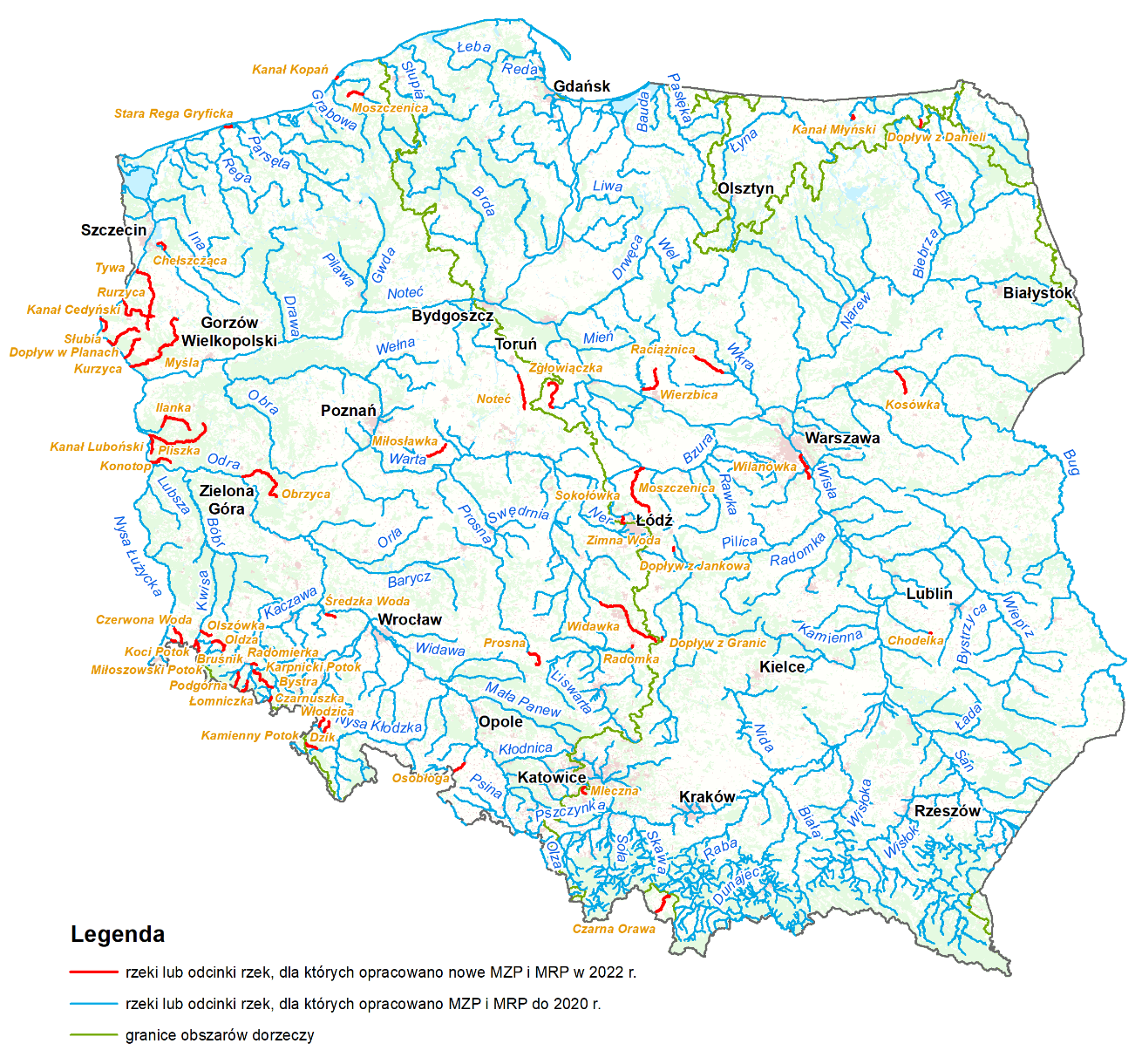
Rivers and river sections with new FHM and FRM in 2022
Moreover, pursuant to Article 171 section 9 of Water Law Act, which provides that maps may be reviewed and, if necessary, updated more frequently than 6 years, flood hazard maps and flood risk maps were updated for indicated river sections and sea shore sections.
Flood hazard maps and flood risk maps drawn up in 2020 included investments that were finished till 2019. In some cases there was a necessity of update flood hazard areas, due to the completion of flood protection investment at a later time. In addition, while working with maps, some problems were reported by users. As a result a new review was made in reported areas and in justified cases maps for indicated sections were updated.
River sections indicated for the update of FHM and FRM in 2022 are shown in picture below.
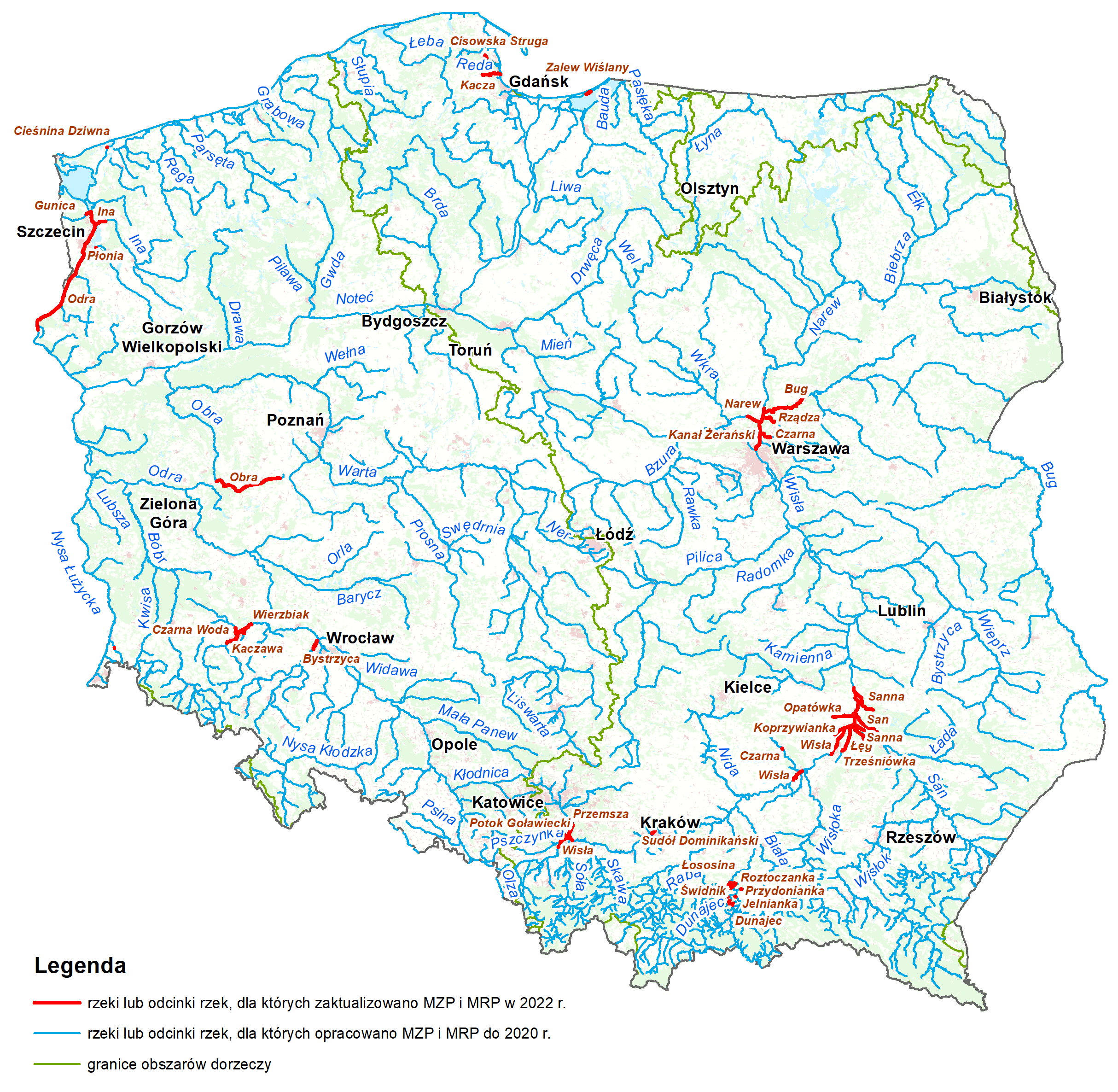
Rivers and river sections with updated FHM and FRM in 2022
FHM and FRM publication, by placing them in the Public Information Bulletin of the Ministry of Infrastructure, took place on 7th September 2022.
Detailed list of areas, for which FHM and FRM was made is in an Appendix nr 6.1 to the Report on review and update of flood hazard maps and floor risk maps (2022).
REPORT ON REVIEW AND UPDATE OF FLOOD HAZARD MAPS AND FLOOD RISK MAPS (2022)
Report on review and update of flood hazard maps and flood risk maps
Annex No. 1 Methodology FHRMs for fluvial floods
Annex No. 1.2 Atribute structure of FHM and FRM data base for fluvial floods
Annex No. 1.3 Cartograpfic version for fluvial floods
Annex No. 3.2 Description of cartographic version of FHM and FRM for the scenario of dam failure
Annex No. 6 Scope of FHM and FRM for particular types of floods
Brochure on flood hazard maps and flood risk maps
Annex No. 2, 4, 5, 7, 8, 9 available only in Polish
UPDATE OF FHM AND FRM (2020)
In 2020 there was an update of flood hazard maps for fluvial floods for about 7 thousand river kilometres and all flood risk maps for fluvial floods for about 14,5 thousand river kilometres. Moreover new maps for about 13,8 thousand river kilometres were made.
For flood from artificial water bearing infrastructure FHM and FRM was made for 7 damming structures.
For floods from the sea and update and new sections was made for about 1,2 thousand river and sea shore kilometres.
Rivers and river sections with new and updated FHM and FRM in 2020
FHM and FRM publication, by placing them in the Public Information Bulletin of the Ministry of Environment and Climate, took place on 22nd October 2020.
REPORT ON REVIEW AND UPDATE OF FLOOD HAZARD MAPS AND FLOOD RISK MAPS (2020) – archival
Detailed methodology, scope and form of development of FHM and FRM in II planning cycle were presented in ’Report on development of review and update of flood hazard maps and flood risk maps in II planning cycle’ including appendices.
Report and Annexes available in Polish
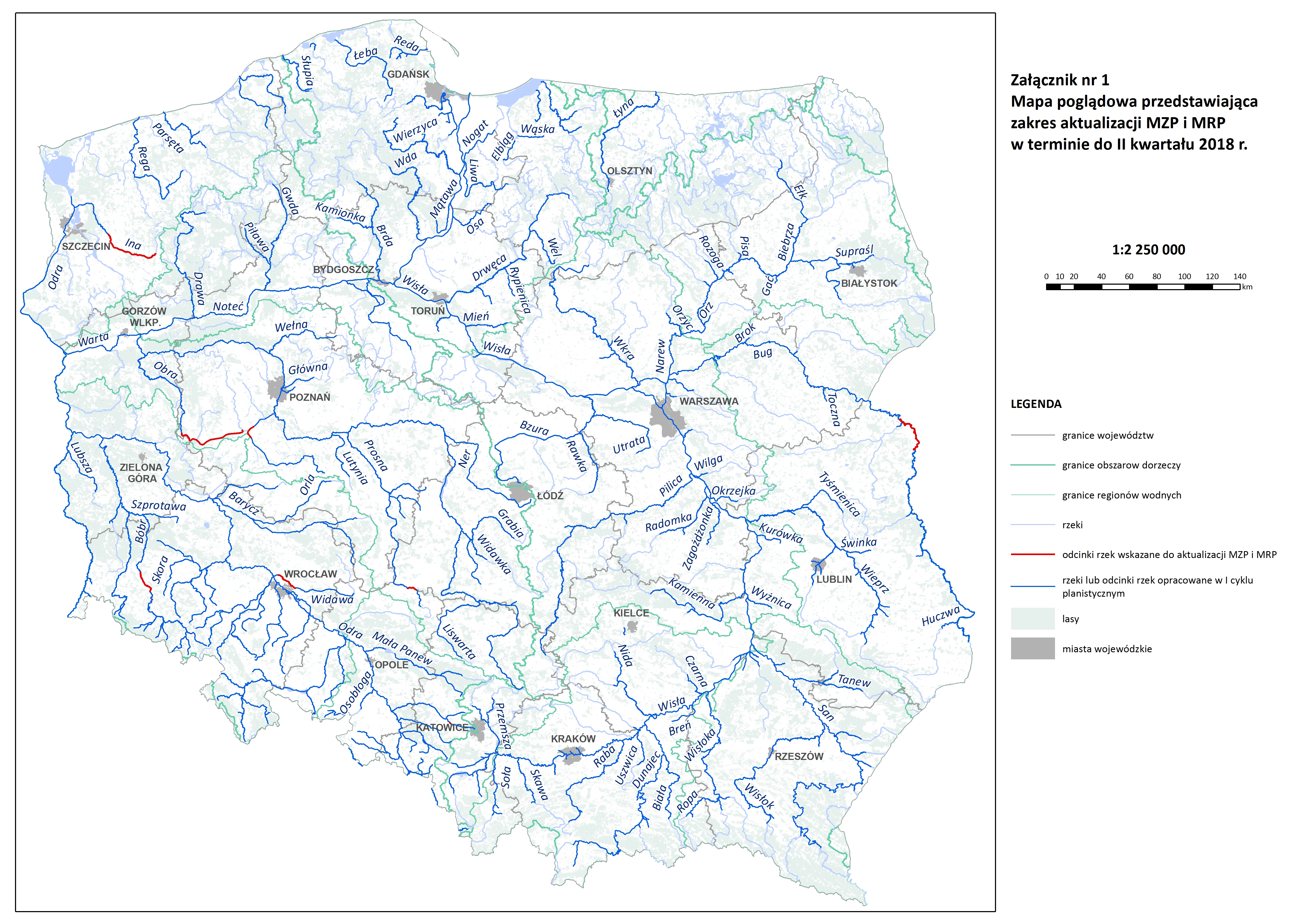
UPDATE OF FHM AND FRM (2018)
Based on art. 171 paragraph 9 of the Act of 20 July 2017 – Water Law, flood hazard maps and flood risk maps for selected river sections were updated. According to the above article maps can be reviewed and, if necessary, updated more often than once every six years, however, in the case of such updates, it is necessary to repeat it in accordance with the principle expressed in the Flood Directive (every six years).
FHMs and FRMs projects prepared by the State Water Holding Polish Waters have been approved by the Minister responsible for water management.
Updated flood hazard maps and flood risk maps were published (19 September 2018) in the Public Information Bulletin of the Ministry of Maritime Economy and Inland Navigation and are available at: http://mapy.isok.gov.pl.
The update applies to selected river sections, where an urgent need to update was identified at the stage of consulting flood risk management plans (PZRP) in 2015, due to, among others, implemented investment projects or significant changes in the terrain. The list of updated river sections is indicated in the report on the update of flood risk and flood hazard maps – part I.
Flood risk and flood hazard maps have been created in accordance with the 1st planning cycle methodology, described in the Report on the preparation of flood hazard maps and flood risk maps (2015). Updated FHMs and FRMs are in accordance with the Regulation of 21 December 2012 on the development of flood hazard maps and flood risk maps (in force on the day of map publication).
The scope of the update are included in the “Report on the preparation of flood hazard maps and flood risk maps – part I (2018)”.
Report on the preparation of flood hazard maps and flood risk maps – part 1
Below, there is a visualisation presenting the scope of the update of flood hazard maps and flood risk maps.