

The Flood Hazard Maps and the Flood Risk Maps in the 3rd cycle

Polish Waters carries out tasks related to the review and update of planning documents in the field of flood risk management in the 3rd planning cycle (2022 – 2027) of the implementation of Directive 2007/60/EC of the European Parliament and of the Council of 23 October 2007 on the assessment and management of flood risks (Floods Directive).
The review and update of flood hazard maps (FHM) and flood risk maps (FRM) in the 3rd planning cycle is financed from the European Funds for Infrastructure, Climate and Environment 2021-2027.
In line with Article 171, paragraph 8 of the Water Law, flood hazard maps and flood risk maps must be reviewed every six years and updated if necessary.
REVIEW OF FHM AND FRM
The purpose of the FHM and FRM review is to identify significant changes in flood hazard and risk and to determine the scope of updating FHM and FRM and the required data.
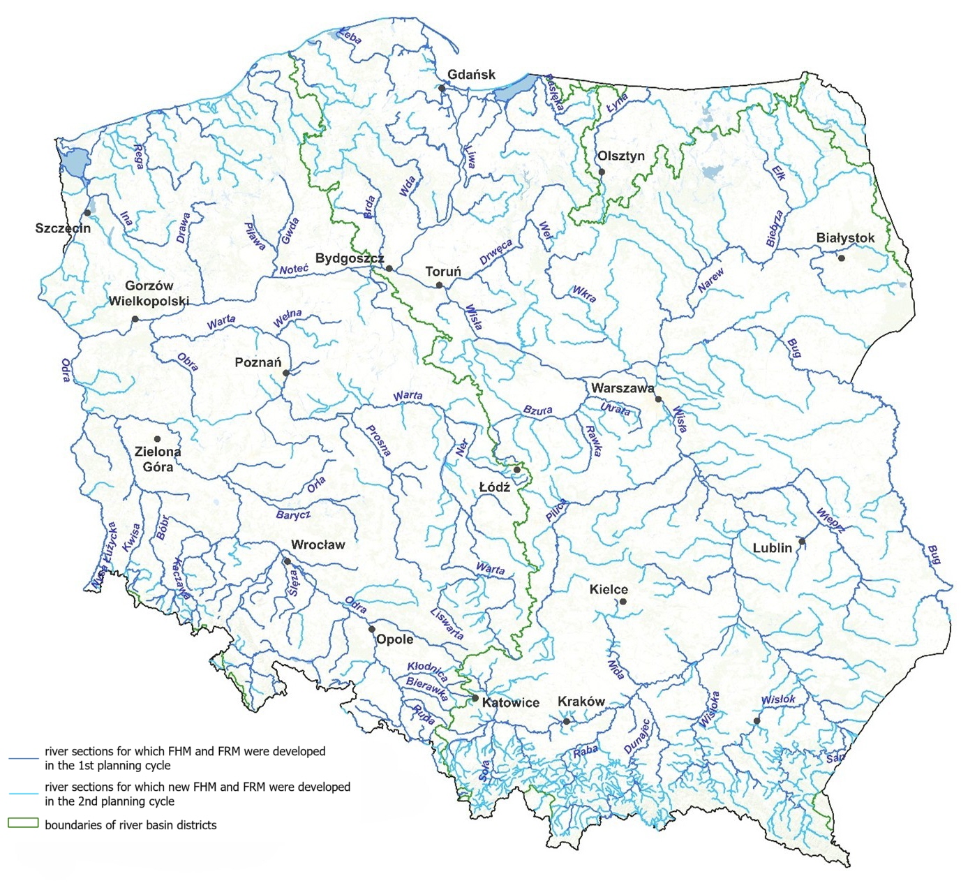
The applicable FHM and FRM developed in the first and second planning cycles include:
1) fluvial floods with a natural exceedance mechanism: approximately 29,300 km of rivers
2) fluvial floods resulting from the complete destruction of flood embankments: approximately 7,000 km of rivers
3) floods resulting from the destruction or damage of dam structures: for 26 flood reservoirs
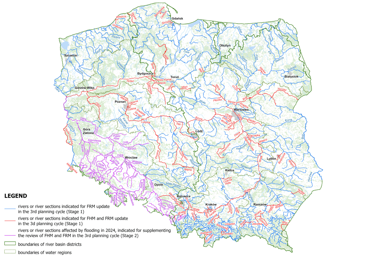
The scope of the FHM and FRM review for river floods is presented in the figure below.
During the review of FHM and FRM for river floods, the following factors are taken into account:
- results of the analysis of comments submitted to the maps (letters from administrative authorities, internal comments from Polish Water, and others)
- results of the review of input data for flood hazard maps
- results of the review of hydraulic models used to determine flood hazard areas
- results of the review of input data for flood risk maps
As part of the review of flood hazard maps, the following was conducted:
- verification of the validity of data used in the hydraulic models,
- inventory of investments implemented since the last FHM was developed until 2025, which impact the extent of flood hazard areas. The survey was conducted among local government authorities, Polish Waters, maritime offices, the General Directorate for National Roads and Motorways, and the Polish State Railways. Information was obtained on topics such as: the construction and reconstruction of water facilities, mobile flood protection systems, the construction and modernization of road and railway engineering structures (e.g., bridges, culverts), and linear road and railway investments affecting floodwater flow conditions.
- analysis of the structure and adopted parameters of hydraulic models, as well as a review of hydrological and meteorological data.
- analysis of changes in topography and land cover, including a digital terrain model, channel cross-sections, and data on land cover within the embankment area.
As part of the review of flood risk maps, the sources and validity of data needed to update the FRM were verified. This data includes, in particular: the estimated number of residents who may be affected by flooding, land use classes, residential buildings, and data for calculating the value of potential flood losses.
A comprehensive assessment of changes for individual river sections was carried out, based on which the rivers were divided into two groups:
- indicated for updating flood hazard maps – in the case of significant changes;
- no need to update flood hazard map – in the case of minor changes that have no impact on the flood hazard level.
THE UPDATE OF FHM AND FRM IN THE 3RD PLANNING CYCLE
The development of FHM and FRM in the 3rd planning cycle is carried out in two stages:
Stage 1, which includes:
- updating FHM and FRM for river floods, within the scope resulting from the FHM and FRM review, excluding river sections affected by the flood in September 2024 – approximately 4,500 km of rivers;
- developing new FHM and FRM for river sections identified as a result of the review and update of the preliminary flood risk assessment in the 3rd planning cycle – approximately 386 km.
In addition, it is planned to update:
- all flood hazard maps to convert flood water elevations from the PL-KRON86-NH elevation system to PL-EVRF2007-NH;
- all flood risk maps due to changes in the data defining flood risk.
Stage 2, which includes:
- supplementing the FHM review for river sections affected by the September 2024 flood in the Middle and Upper Oder and Little Vistula water regions to reflect the impact of changes resulting from the flood;
- updating FHM and FRM for river sections affected by the September 2024 flood. The scope of this update will be based on the supplemented FHM review.
The river sections to be updated in FHM and FRM in the 3rd planning cycle are shown in the figure below.